
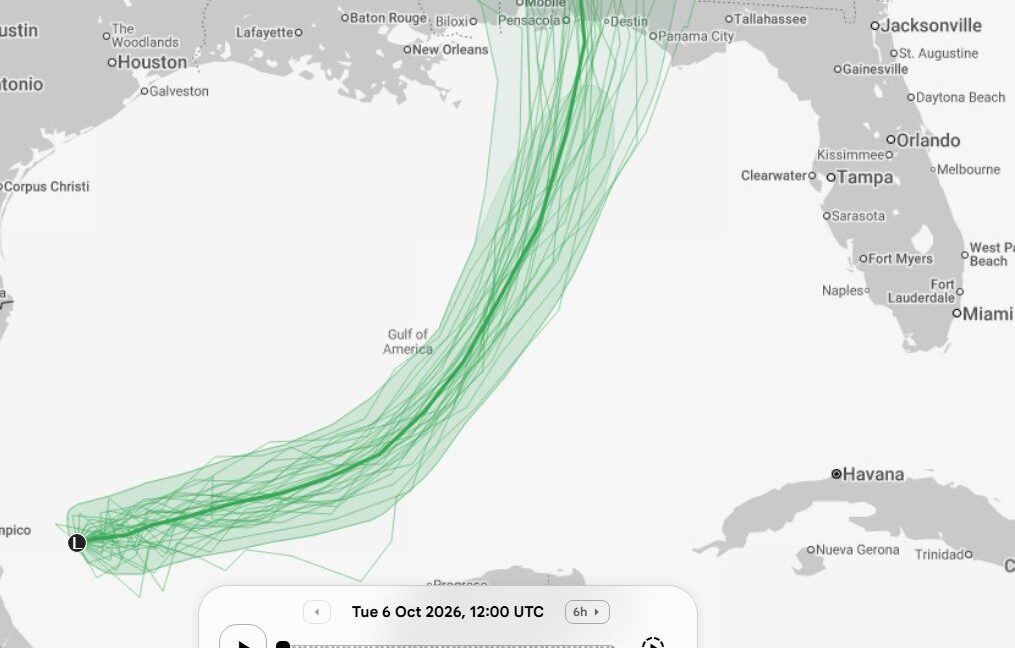
A low-pressure system in the western Gulf of Mexico should soon become a tropical storm, and based on the latest forecast modeling, it has a decent chance of becoming a hurricane.
Normally, a hurricane forming in early October would not be particularly noteworthy. However, this year the development of a hurricane would be a big deal—because it has not happened yet.
In the modern hurricane record—an era dating to about World War II when there has been aircraft reconnaissance and later continuous satellite coverage—there has never been an Atlantic season without a hurricane, and no season has gone this late without one forming.
There have been two years, 1907 and 1914, in which no hurricanes were recorded. However, that does not definitively mean there were no hurricanes. Before aircraft flew across the Atlantic, our records almost certainly missed hurricanes over the open ocean.
The Atlantic hurricane season, nominally, runs from June 1 through November 30. However, the vast majority of hurricanes form between mid-August and mid-October, so the window of opportunity for one this season is closing.
The Atlantic tropics have been exceptionally quiet this year, largely due to a strengthening El Niño that is expected to become historically strong. Typically, El Niño produces high levels of wind shear over the tropical Atlantic, which disrupts the organization of tropical systems. That has definitely been the case this year, as it has been the quietest season to date by most metrics.
The developing tropical system in the Gulf, which would take on the name Isaias should it form in the next couple of days, does not have entirely smooth sailing. There is dry air and wind shear to its north. But there is a path over the next few days that could see it skirt eastward around this. On such a track it would traverse the very warm waters of the central Gulf, which are between 28° and 30° C, well above normal for this time of year.
By remaining far enough south of the wind shear over the northwest Gulf, Isaias would have a couple of days during which to get organized and strengthen into a hurricane. In recent runs, most of our available guidance has become more bullish on this scenario, with some potential for even a major hurricane.
Until such time as there is a well-defined center of circulation, however, there is a great deal of uncertainty about how strong Isaias might get. In terms of where it will go, most of the available model guidance suggests it will make landfall between southeastern Louisiana and the Florida Panhandle on Friday or Saturday.
Heavy rainfall is a certainty with this storm, but the level of threat from sustained winds and storm surge will be dependent upon the extent to which Isaias can get its act together.